|
 The Valley landscape is comprised of a variety of spaces that have been
shaped by people over time. Some of the spaces, such as farmland, forest
land, and industrial land, have economic characteristics. Many have ecological
or natural characteristics, such as wetlands, lakes, or wooded slopes.
Other spaces are symbolic, expressing shared values. For example, throughout
the Valley, Catholic churches rise above the surrounding buildings of
each town, thus amplifying the focal role of religion in daily life. Connection
to religion is further expressed in the landscape by numerous public and
private shrines and grottoes.
The Valley landscape is comprised of a variety of spaces that have been
shaped by people over time. Some of the spaces, such as farmland, forest
land, and industrial land, have economic characteristics. Many have ecological
or natural characteristics, such as wetlands, lakes, or wooded slopes.
Other spaces are symbolic, expressing shared values. For example, throughout
the Valley, Catholic churches rise above the surrounding buildings of
each town, thus amplifying the focal role of religion in daily life. Connection
to religion is further expressed in the landscape by numerous public and
private shrines and grottoes.
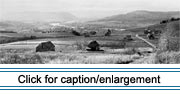
Some spaces have resulted from everyday actions by individuals, like
plowing a field, cutting a woodlot, or tearing down a twin barn. Still
other spaces in the Valley were planned through deliberate political or
governmental action. The siting of church buildings has often been a political
decision. Historically, the governments of Great Britain and then the
United States imposed a political landscape that is still evident. Other
governmental or planned spaces are also evident in the Valley, such as
U.S. Route 1 or the Fort Kent blockhouse.
 The
Upper St. John Valley is a distinctive entity: long-time residents of
Maine, some a day's drive away, know the area simply as "the Valley."
The river valley is a compact landform characterized by the line of the
St. John River flowing between highlands that rise approximately 400-600
feet above the valley floor. The bounds of "the Valley," however, are
defined more by cultural ties than by topography. The local concept of
the Valley extends up to 15 miles south from the river to the "back settlements"
on the highlands. These settlements include Daigle, Sinclair, St. Agatha,
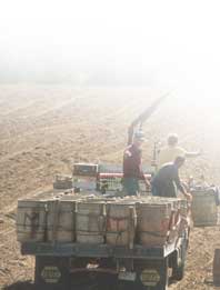
and Lavertu Settlement where the agricultural use of Valley land is evident
in the valley, such as in the sweeping potato fields. Woodlands surround
and define the existing fields, often reaching to the shores of the St.
John River or, in the back settlements, to lake shores. The alternating
forests and fields accentuate the long linear lots. Woody seedlings are
invading the former agricultural land along the river which, if unchecked,
will grow into forests. The
Upper St. John Valley is a distinctive entity: long-time residents of
Maine, some a day's drive away, know the area simply as "the Valley."
The river valley is a compact landform characterized by the line of the
St. John River flowing between highlands that rise approximately 400-600
feet above the valley floor. The bounds of "the Valley," however, are
defined more by cultural ties than by topography. The local concept of
the Valley extends up to 15 miles south from the river to the "back settlements"
on the highlands. These settlements include Daigle, Sinclair, St. Agatha,
and Lavertu Settlement where the agricultural use of Valley land is evident
in the valley, such as in the sweeping potato fields. Woodlands surround
and define the existing fields, often reaching to the shores of the St.
John River or, in the back settlements, to lake shores. The alternating
forests and fields accentuate the long linear lots. Woody seedlings are
invading the former agricultural land along the river which, if unchecked,
will grow into forests.
|
 |
 |
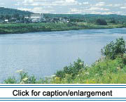
Ribbons of roads and railroads embrace the St. John River, restricting
both  visual
and physical access. U.S. Route 1 parallels the river, and connects the
three Valley commercial centers of Van Buren, Madawaska, and Fort Kent,
along with other river settlements. The U.S. highway reaches its northern
terminus in Fort Kent. Abandoned potato warehouses and an abandoned starch
factory along the railroad lines are reminders of the area's former agricultural
heyday. visual
and physical access. U.S. Route 1 parallels the river, and connects the
three Valley commercial centers of Van Buren, Madawaska, and Fort Kent,
along with other river settlements. The U.S. highway reaches its northern
terminus in Fort Kent. Abandoned potato warehouses and an abandoned starch
factory along the railroad lines are reminders of the area's former agricultural
heyday.
The climate of the Upper St. John Valley is characterized by short, cool
summers and long, cold winters. Temperatures vary widely within the larger
area of the river basin. However, average summer temperatures range between
50 and 70 degrees Fahrenheit, while winter temperatures reach below 0
degrees Fahrenheit about 50 days each year. More than 100 inches of snow
fall annually.
|
|