|
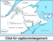
 During the 1780s, Acadians moved from the Fredericton, New Brunswick,
area northwest along the St. John River, settling the upper shores. They
were joined by immigrants from "Lower Canada," as the St. Lawrence River
Valley around Kamouraska was known at that time. Today French-speaking
residents of the St. Lawrence River Valley are collectively referred to
as "Québecois"; however, the province of Québec had not yet been established
during the initial settlement of the Valley by the French. Therefore,
these immigrants from Lower Canada are hereinafter referred to as "French
Canadians."
During the 1780s, Acadians moved from the Fredericton, New Brunswick,
area northwest along the St. John River, settling the upper shores. They
were joined by immigrants from "Lower Canada," as the St. Lawrence River
Valley around Kamouraska was known at that time. Today French-speaking
residents of the St. Lawrence River Valley are collectively referred to
as "Québecois"; however, the province of Québec had not yet been established
during the initial settlement of the Valley by the French. Therefore,
these immigrants from Lower Canada are hereinafter referred to as "French
Canadians."
The governors of Québec and New Brunswick had promised land to prospective
settlers of the Upper St. John Valley to strengthen the mail route between
the two provinces; this was likely a motivation for some settlement. Historians,
however, do not agree on the principal cause of Acadian migration up the
St. John River. Some scholars, including Roy (1982), emphasize that the
Acadians were dislodged from the lower valley to make room for the British
Empire Loyalists, who were arriving from the former colonies to the south
following the American Revolution. According to Wade (1972), within seven
or eight years of the arrival of the Loyalists, Acadians moved out of
the lower valley, mainly to acquire more land and to secure the services
of a priest. Craig concurs with Wade and also stresses the Acadians' desire
to keep their families intact and settle their sons on nearby farms (Craig
1983a, 1986a, 1986b).
 As
it does today, family played an important role in the life of the early
French settlers of the Upper St. John Valley. The Acadians of the lower
reaches of the St. John River had spent the deportation years in exile
in Québec, and many of them had married French Canadians in the Kamouraska
area before returning to the St. John during the 1760s and 1770s. In the
1780s, all the Acadians with French-Canadian relatives chose to relocate
along the Upper St. John River, while the majority of those with no family
ties to French Canadians moved instead to settlements in eastern New Brunswick
(Craig 1983b). Regardless of their motivation, the Acadians did not leave
the lower valley empty-handed. Most had grants to the land they occupied
and sold them to Loyalists. As
it does today, family played an important role in the life of the early
French settlers of the Upper St. John Valley. The Acadians of the lower
reaches of the St. John River had spent the deportation years in exile
in Québec, and many of them had married French Canadians in the Kamouraska
area before returning to the St. John during the 1760s and 1770s. In the
1780s, all the Acadians with French-Canadian relatives chose to relocate
along the Upper St. John River, while the majority of those with no family
ties to French Canadians moved instead to settlements in eastern New Brunswick
(Craig 1983b). Regardless of their motivation, the Acadians did not leave
the lower valley empty-handed. Most had grants to the land they occupied
and sold them to Loyalists.
|
 |
 |
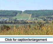
The exact date of the arrival of the first settlers at "Madawaska," as
the Upper St. John Valley region was known, remains a subject of speculation.
The best-known history of the area, written in 1920 by Father Thomas Albert
([1920] 1985), claims that the first Acadian landing occurred on the southern
shore of the valley in 1785, at what is now St. David parish, in the present-day
town of Madawaska, Maine. Contemporary research has confirmed that the
first petition to the New Brunswick legislature requesting land in the
Upper St. John Valley was dated 1785 (Craig 1988: 127). While the precise
location of the first arrival is unknown, Maine Acadians generally recognize
the site in St. David parish as being symbolic of the landing.
In 1786 one of the original settlers was recognized as a land agent by
the New Brunswick government, and was authorized to distribute parcels
of land to prospective settlers in the Upper St. John Valley (Desjardins
1992: 38). His instructions from Fredericton specified that settlers from
Lower Canada would be permitted to obtain land in the area. Families from
Kamouraska and Riviére-Ouelle began arriving the same year. French Canadians
with names such as Dubé and Soucy therefore joined the Acadian settlers,
such as the Cyr and Daigle families, during the first years of settlement
in the Upper Valley.
By 1790, according to a census taken by the governor of Lower Canada,
there were 174 inhabitants in the Upper St. John Valley. According to
parish tithing records for 1799, the population of the Upper St. John
Valley was 331, half of whom were under 12 years of age (Craig 1988: 127).
By 1800, the Valley included 80 families: 32 headed by an Acadian couple,
20 by a French-Canadian couple, and 28 by an Acadian/French-Canadian couple.
French Canadians kept coming, in small numbers at first, then in larger
ones after lumber camps opened in the vicinity during the winter of 1823-1824.
Most of them decided to stay and establish a farm (Craig1986a, 1988).
A few Americans from the Kennebec Valley area in Maine also found their
way to the Valley, as did a few New Brunswickers of Scots-Irish origin.
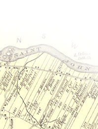
 Settlement
spread along the river, first to the west, then to the east. By 1831 there
were about 2,500 settlers along a 45-mile stretch of the Valley, from
the mouth of the Fish River to a few miles east of Violette Brook (Deane
and Kavanagh 1831). The banks of the larger tributaries, like the Madawaska,
the Green (Verte), the Grand (Grande), and the Fish, were settled early,
especially near their confluences with the St. John. Smaller brooks flowing
into the St. John also attracted early settlement. The "flats," or floodplains,
along the banks of the river were soon developed into farms, and clearing
for new farmlands pushed progressively farther from the riverbanks. A
census completed in 1840 reported a total population of 3,460, encompassing
1,584 people on the north bank of the St. John River and 1,876 on the
south bank (Craig 1983b: 108). Settlement
spread along the river, first to the west, then to the east. By 1831 there
were about 2,500 settlers along a 45-mile stretch of the Valley, from
the mouth of the Fish River to a few miles east of Violette Brook (Deane
and Kavanagh 1831). The banks of the larger tributaries, like the Madawaska,
the Green (Verte), the Grand (Grande), and the Fish, were settled early,
especially near their confluences with the St. John. Smaller brooks flowing
into the St. John also attracted early settlement. The "flats," or floodplains,
along the banks of the river were soon developed into farms, and clearing
for new farmlands pushed progressively farther from the riverbanks. A
census completed in 1840 reported a total population of 3,460, encompassing
1,584 people on the north bank of the St. John River and 1,876 on the
south bank (Craig 1983b: 108).
|
|