|
 Although
Great Britain had exercised authority over "Madawaska" since its founding
in 1785 (administering it as a part of New Brunswick), jurisdiction over
the entire territory was disputed due to the ambiguous wording of the
1783 Treaty of Versailles that set the boundary between the United States
and British North America (Albert [1920] 1985: 90). In addition to the
ambiguity, there was great interest in the timber resources of the region
by both Americans and Britons, and logging operations were underway on
both sides of the river when the State of Maine was created in 1820. In
1826, logging licenses were suspended pending settlement of the border
dispute (Craig 1988: 130). The conflict that arose during the following
years was a source of hostilities between Great Britain and the United
States that ranged from a brief period of armed conflict in the "Bloodless"
Aroostook War, to several years of often acrimonious diplomatic disputes
and negotiations in state, provincial, and national capitals (McDonald
1990). Although
Great Britain had exercised authority over "Madawaska" since its founding
in 1785 (administering it as a part of New Brunswick), jurisdiction over
the entire territory was disputed due to the ambiguous wording of the
1783 Treaty of Versailles that set the boundary between the United States
and British North America (Albert [1920] 1985: 90). In addition to the
ambiguity, there was great interest in the timber resources of the region
by both Americans and Britons, and logging operations were underway on
both sides of the river when the State of Maine was created in 1820. In
1826, logging licenses were suspended pending settlement of the border
dispute (Craig 1988: 130). The conflict that arose during the following
years was a source of hostilities between Great Britain and the United
States that ranged from a brief period of armed conflict in the "Bloodless"
Aroostook War, to several years of often acrimonious diplomatic disputes
and negotiations in state, provincial, and national capitals (McDonald
1990).
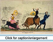 John
Baker, one of several Americans from the Kennebec Valley who had begun
moving into the Upper St. John Valley in 1817, became one of the standard-bearers
for claims to the area by Maine and the United States (Albert [1920] 1985:
92-93). On July 4, 1827, Baker organized an Independence Day celebration
from his home on the north shore of the river and raised an American flag
to challenge British authority (Dubay 1983: 26-27). In late September
that same year, Baker, an American citizen, was arrested, tried, in Fredericton,
New Brunswick, and sentenced to three months of imprisonment for rebellious
activities. Prompted by the arrest and desiring to establish the sovereignty
of Maine, the newly installed state government sought action from the
federal government in Washington. John
Baker, one of several Americans from the Kennebec Valley who had begun
moving into the Upper St. John Valley in 1817, became one of the standard-bearers
for claims to the area by Maine and the United States (Albert [1920] 1985:
92-93). On July 4, 1827, Baker organized an Independence Day celebration
from his home on the north shore of the river and raised an American flag
to challenge British authority (Dubay 1983: 26-27). In late September
that same year, Baker, an American citizen, was arrested, tried, in Fredericton,
New Brunswick, and sentenced to three months of imprisonment for rebellious
activities. Prompted by the arrest and desiring to establish the sovereignty
of Maine, the newly installed state government sought action from the
federal government in Washington.
The Governor of New Brunswick, Sir John Harvey, 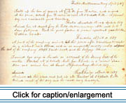 visited the disputed territory and reported in 1839, "the Acadians of
Madawaska have manifested to me on numerous occasions (and again very
recently) their unanimous and spontaneous desire to remain under the jurisdiction
of New Brunswick" (Albert [1920] 1985: 100). Writings from the period
indicate the inhabitants feared that they might lose possession of their
lands if their territory became a part of the United States (Dubay 1983:
29).
visited the disputed territory and reported in 1839, "the Acadians of
Madawaska have manifested to me on numerous occasions (and again very
recently) their unanimous and spontaneous desire to remain under the jurisdiction
of New Brunswick" (Albert [1920] 1985: 100). Writings from the period
indicate the inhabitants feared that they might lose possession of their
lands if their territory became a part of the United States (Dubay 1983:
29).
|
 |
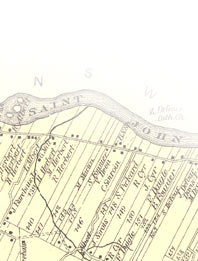 |
Whatever the wishes of the inhabitants, the boundary dispute was settled
through diplomacy and arbitration. The matter was resolved in 1842 when
Lord Ashburton of Great Britain and Daniel Webster of the United States
negotiated a treaty (known as the Webster-Ashburton Treaty) that established
the St. John and St. Francis rivers as the international boundary above
Grand Falls.
Following the border settlement, some settlers arriving from Lower Canada
preferred to remain on the New Brunswick side rather than cross into Maine
(Albert [1920] 1985: 116). Due to a reduction in immigration, population
increase was slower on the American side during the 1840s and 1860s. The
settlement of the Maine side of the valley did, however, continue to expand.
Allen (1981: 87) summarizes the expansion as follows:
Some people moved up the Fish River along a newly created road to
the south. Also, by the 1850s logging trails penetrated the broad hill
country east of Frenchville, and after 1860 this area received its first
farm families. Ultimately, these back settlements would be spread over
the land some ten miles south of the river. By 1892, the settlement
encompassed Hamlin on the east and St. Francis on the west, but the
general direction of the expansion was to the south. Wallagrass, Eagle
Lake, and Winterville were then well populated.
 Expansion to the southeast brought people of French descent in contact
with English-speaking settlers in eastern Aroostook County, and with Swedish
immigrants who had founded the town of New Sweden (1871) and later the
town of Stockholm. On the western extremity of French settlement in the
Valley, near the mouth of the St. Francis River, the French population
came in contact with English-speaking loggers of Scots-Irish descent who
had migrated there from New Brunswick (Allen 1981: 87).
Expansion to the southeast brought people of French descent in contact
with English-speaking settlers in eastern Aroostook County, and with Swedish
immigrants who had founded the town of New Sweden (1871) and later the
town of Stockholm. On the western extremity of French settlement in the
Valley, near the mouth of the St. Francis River, the French population
came in contact with English-speaking loggers of Scots-Irish descent who
had migrated there from New Brunswick (Allen 1981: 87).
According to William Ganong (1901) the Webster-Ashburton Treaty of 1842,
which gave approximately two-thirds of the disputed territory to the United
States, was actually favorable to Great Britain because, based on the
wording of the Treaty of Versailles, the State of Maine had a strong claim
to the entire territory. However, the boundary settlement was unfortunate
in that it divided a compact and homogeneous population between two governments
and created an "unnatural" territorial boundary. Today Maine Acadians
generally ignore the international boundary with regard to family and
social ties. Yet, the St. John River has formed a portion of the northern
border of the United States since 1842. Maine Acadian identity has come
to embrace being both "American" and "Acadian."
|
|